
بررسی و پیش بینی دمای سطح زمین (LST) بر اراس دادههای سنجش از دوری طی دوره ۱۹۸۷ تا ۲۰۳۰ (مطالعه موردی، شهر ریکیاویک، ایسلند)
نویسندگان:
Mohammad Mansourmoghaddam, Iman Rousta, Mohammad Sadegh Zamani, Haraldur Olafsson
چکیده:
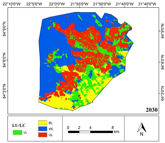
Observing the state and changes of land cover (LC) is critical for assessing the status and changes of ecosystems such as urban development. Remote sensing can extract useful data from a large region regularly and at the same time. The present study has used Landsat 5 and 8 images to derive LC classification and Land Surface Temperature (LST) maps of Reykjavik city for four years 1987, 1995, 2006, and 2019. Satellite images were classified into four major land-cover classes using the Artificial Neural Network classification (ANN) algorithm. Then, calculations including the LST and the distance from the water were calculated for each study period. Finally, using the Markov chain, the prediction of land cover classes and LST classes for 2030 was obtained. The results have shown an average of 21.5% (8.2 km2), 71% (32.9 km2), -62.9% (43.7 km2), and 3.4% (2.6 km2) growth for Urban Areas (UA), Vegetation Land (VL), Bare Lands (BL), and Water Lands (WL) of Reykjavik evaluated LC classes. Reykjavik LC forecasting shows that UA will have had a 38.5% (8.2 km2), VL a -43% (34.1 km2), BL a 14.7% (3.8 km2), and WL a 14.8% (11.9 km2) by 2030. The mean of LST in this area has risen by 67.5% (7.7 °C) during this period. This is also supported by the findings of the analysis of the NDVI and LST connection. According to the research, the LST and the NDVI value of 0.1 to 0.7 have a positive relationship in this area. However, there is a negative correlation between LST with NDVI values of 0.8 and 0.9. The results showed that the mean of LST was also influenced by the distance from WL water bodies. The LST has grown by a mean of 0.7 of correlation as the distance from WL has increased. The results of this research will be useful in order to get an overview of the past and present situation and plan for the control of heat islands and land cover changes in Reykjavik.

hello world
hello world
عالی موفق باشید 👏
سپاس از محبت و توجه شما 🙏🏻